
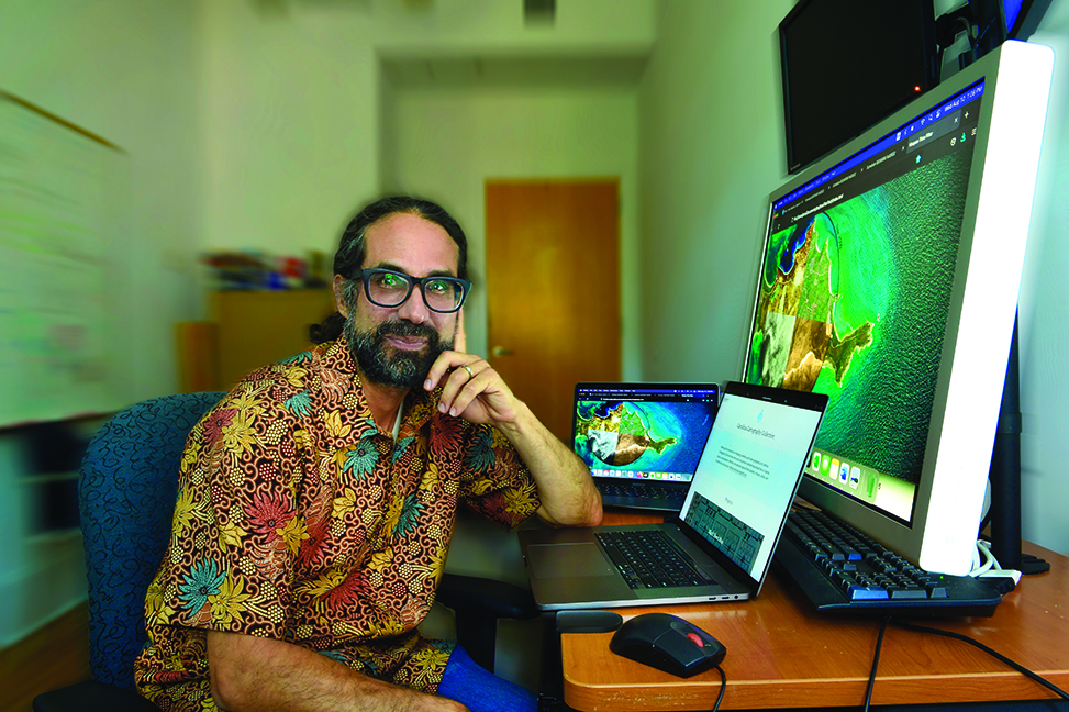
“Mapping is both a scientific endeavor and a humanistic process that can build conversations,” says geographer Javier Arce-Nazario. (photo by Donn Young)
Geographer Javier Arce-Nazario uses innovative mapping technologies to help communities in the Galapagos Islands, Puerto Rico and beyond.
Maps are vital in connecting one place to another, and technology makes this possible in mere seconds. Javier Arce-Nazario sees an equally vital use for maps: supporting communities.
Arce-Nazario, associate professor of geography, is leading a research effort to help farmers in the Galapagos Islands, an Ecuadorian archipelago formed by volcanoes and hundreds of miles from the mainland. His work is affiliated with UNC-Chapel Hill’s Center for Galapagos Studies, which conducts research and outreach in partnership with Ecuador’s Universidad San Francisco de Quito.
“From the scientific point of view, we are trying to understand the agricultural uses of small islands,” he said. “These islands often have to import most of their food, but the farmers still have very important roles, especially in emergency situations. It’s important to learn how to make the islands more sustainable.”
Drone technology is the foundation of maps that give farmers the ability to see their agricultural landscape in a new way. Few photographic archives exist to enable mapping of how the islands have changed over time. The farmers are making up for that by sharing their knowledge of this history.
“Engaging with farmers in the Galapagos has been easy because they see a lot of use for the mapping technology,” he said. “That makes you feel good because what you are doing has value for them. The first thing is that they see their land looking so beautiful from above. The second thing is that they now have a map for planning how they manage their spaces where they are working.”
Arce-Nazario’s innovative work in mapping began when he was researching his doctoral dissertation on “how humans and rivers shape the Peruvian Amazon landscape.” He received his master’s and doctoral degrees in ecology, evolution and environmental biology from Columbia University, after receiving his bachelor’s degree in biology from the University of Puerto Rico, Rio Piedras Campus.
Arce-Nazario joined the faculty of the University of Puerto Rico at Cayey in 2009. He received the Presidential Early Career Award for Scientists and Engineers in 2012; the highly prestigious U.S. government honor recognized his research on climate-related water challenges and his scientific outreach to communities along Puerto Rico’s La Plata River.
As an expert in landscape ecology, Arce-Nazario regularly spoke to community groups, and some of their meeting spaces featured photographs of Puerto Rico spanning several decades. That led him to consider how mapping could create a compelling view of how Puerto Rico’s built landscape had evolved over the decades. His research and outreach, in collaboration with UPR-Cayey’s Environmental Cartography Collective, culminated in a 2017 exhibit — geo/visual/island — at the Institute of Puerto Rican Culture.
A faculty member at UNC-Chapel Hill since 2017, Arce-Nazario maintains his connection to UPR-Cayey as an adjunct professor.
Undergraduate and graduate students are making important contributions to mapping research, he said, adding that some UNC students who have taken his courses formed a mapping organization. The Carolina Cartography Collective created an exhibit, Geovisualizing Vieques, covering landscape changes on the Puerto Rican island over 150 years — which was held on Vieques from December 2021 to May 2022.
“The Vieques exhibit was started by students,” Arce-Nazario said. “They organized it, they traveled there, and they talked to stakeholders. They were essential in its design and creation.”
The collective, which now includes both UNC students and alumni, also has embarked on a project to map Black-founded communities in the United States. Arce-Nazario said mapping needs the perspectives of community members and stakeholders.
“Mapping is both a scientific endeavor and a humanistic process that can build conversations. We want to explore new ways of mapping and new ways to engage.”
By Deb Saine ’87
Published in the Fall 2022 issue | Tar Heels Up Close
Read More

Feed your reading habit: More books by College faculty and alumni
Inclusive Teaching: Strategies for Promoting Equity in the College Classroom…
Creating community in the classroom
Ariana Vigil teaches and conducts research in Latina/o literature, militarization,…
Virtual ‘zine’ highlights Southeast Asian American writers in N.C.
When junior Britney Hong began planning her Summer Undergraduate Research…